Tuesday, 10 December 2024

Day 15 Tuesday 10th December 2024, Castries, La Lucia - the Caribbean Cruise


Our Eco forest tour was amazing, both Michael and I absolutely loved the experience. The aerial tram ride allowed us to glide above the treetops, providing a unique perspective of the rainforest. The tram is designed for comfort and safety, accommodating small groups.


Scenic Views: As we climbed, we enjoyed panoramic views of the surrounding mountains, valleys, and the Caribbean Sea. Mellissa (Mel) maintained informative commentary on the local flora and fauna, throughout the tour, highly recommended.


Wildlife Spotting: The slow pace of the tram allowed us to spot a humming bird, good luck seeing it in this picture.

Zipline Experience:
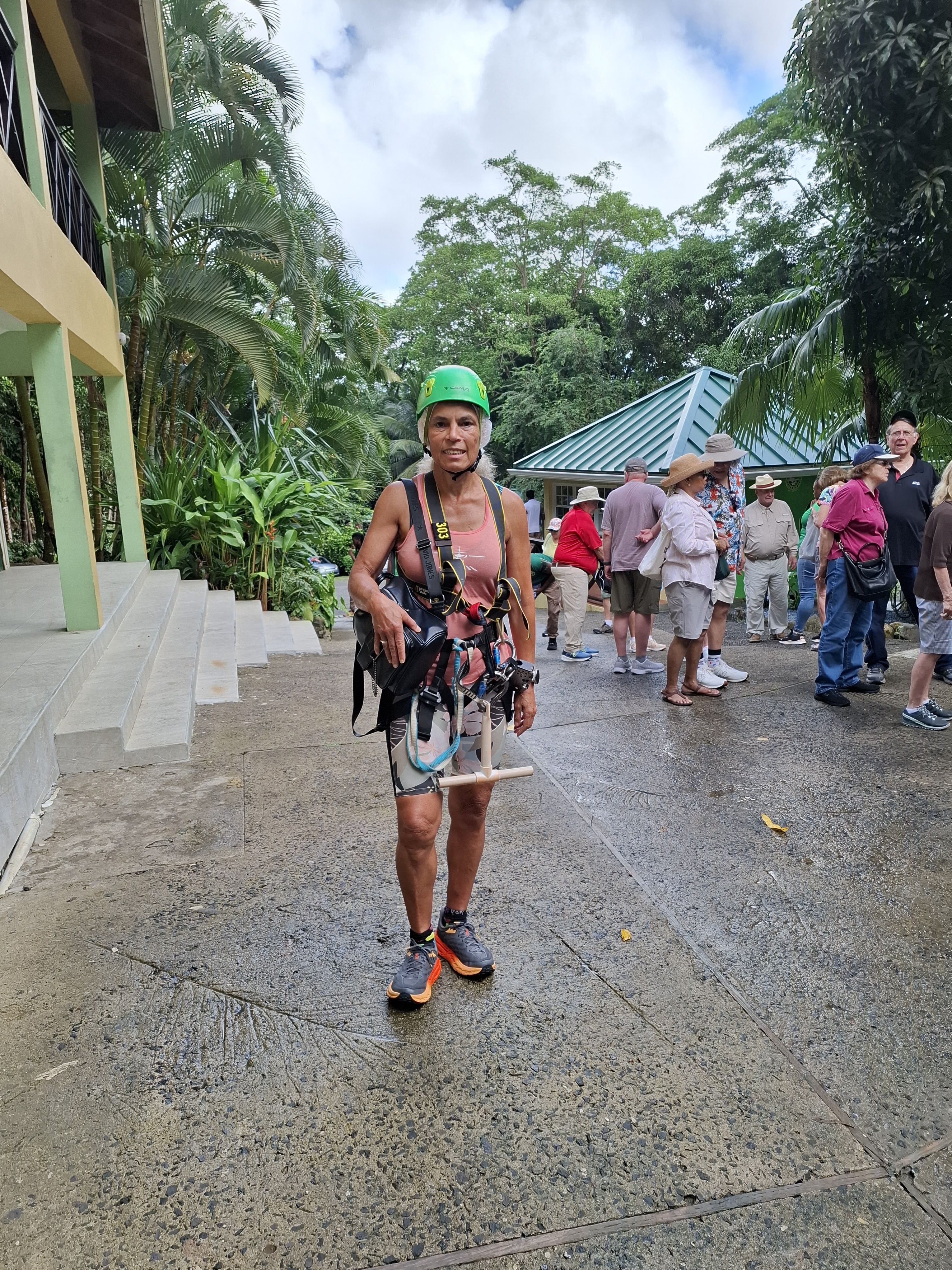
The zipline course featured 6 lines that traverse the rainforest canopy, offering an adrenaline-pumping experience. Participants can soar through the air, feeling the rush of wind and the thrill of height.
 
Nature Integration: Many zipline courses are designed to blend seamlessly with the environment, allowing participants to experience the beauty of the rainforest from a new vantage point.
Ana Maria
Michael
Castries, the capital of Saint Lucia, is surrounded by lush rainforests that are part of the island's rich biodiversity. The rainforests are home to a variety of trees, including towering mahogany, ferns, and the iconic Caribbean pine. These forests provide a habitat for numerous bird species, making them a popular spot for birdwatching.


Birds
Saint Lucia Parrot (Amazona versicolor): This endemic species is a symbol of the island and is known for its vibrant green and blue feathers. Conservation efforts have helped increase its population.
Tropical Mockingbird: Commonly found in various habitats, this bird is known for its melodious song and adaptability.
Antillean Crested Hummingbird: A small, colorful bird that is often seen flitting around flowers in the rainforest.

Trees
Mahogany: Known for its beautiful wood, mahogany trees can grow quite tall and are a significant part of the rainforest ecosystem.
Cocoa Trees: Saint Lucia is known for its cocoa production, and these trees thrive in the humid rainforest environment.
Banana Trees: While not native, banana trees are commonly found and contribute to the island's economy.

Stories and Culture
The rainforests of Saint Lucia are steeped in local folklore and stories. The island's indigenous Carib and Arawak peoples have long regarded the forests as sacred spaces, filled with spirits and myths. Tales of the "Soufrière" volcano and the "Pitons" often intertwine with the natural landscape, creating a rich tapestry of cultural narratives.

Additionally, the rainforests are vital for ecotourism, attracting visitors interested in hiking, birdwatching, and experiencing the island's natural beauty. Guided tours often share stories of the flora and fauna, as well as the historical significance of the area, including the impact of colonialism and the preservation efforts for endangered species.
The local beer Piton

in a 350 year tree unfortunately strangled to death by some other tree

Ready for Ziplining, so cool, so much fun.

Day 14 Monday 9th December 2024, Fort de France, Martinique - the Caribbean Cruise

Fort-de-France is the capital city of Martinique, an island located in the Caribbean Sea. It is known for its vibrant culture, rich history, and beautiful landscapes. The city features a mix of French and Caribbean influences, evident in its architecture, cuisine, and local traditions.

Key attractions in Fort-de-France include:

La Savane: A large public park in the city center, perfect for relaxation and enjoying local events.


Lovely murals found all over the city


Fort Saint-Louis: A historic fort built in the 17th century, offering insights into the island's colonial past.


St. Louis Cathedral: A striking neo-Gothic cathedral known for its unique architecture and stained glass.

The Schoelcher Library: A beautiful building dedicated to the abolitionist Victor Schoelcher, featuring a stunning interior and a rich collection of books.

Local Markets: The Grand MarchΓ© is a bustling market where visitors can find local produce, crafts, and souvenirs.

Fort-de-France serves as a cultural hub, hosting various festivals and events throughout the year, showcasing music, dance, and art that reflect the island's diverse heritage. The city's waterfront offers picturesque views and is a popular spot for both locals and tourists.

Very narrow streets

Martinique itself is known for its stunning beaches, lush rainforests, and volcanic landscapes, making it a popular destination for nature lovers and adventure seekers. The island's economy is primarily based on tourism, agriculture, and rum production.

Overall, Fort-de-France is a vibrant and dynamic city that represents the heart of Martinique, blending natural beauty with rich cultural experiences.

Our local beer choices for the day, Lorraine and an artisanal local beer called BAM.

Cosmopolitan streets with lots of local shops and markets

This mural signifies more talking and less fighting.


Monday, 9 December 2024

Day 13 Sunday 8th December 2024, Point a Pitre, Guadeloupe - the Caribbean Cruise


Pointe-Γ -Pitre itself is a beautiful, brightly coloured riot of colour, filled with sumptuous smells and sounds to match. As an overseas territory of France, the culture in Guadeloupe is a mixture of French and Caribbean.
Built on top of what was once a patch of very swampy land, Pointe-a-Pitre’s history has been fraught with disasters. They’ve been through earthquakes, hurricanes and fires- plus a few cholera epidemics for good measure- but these copious amounts of calamities haven’t affected the beating heart of the city, and Guadeloupe cruise port is one of the best Caribbean ports of call for immersing yourself in local culture.
Although parts of the city consist of ramshackle wooden houses and shuttered windows, amongst all this are great big concrete skyscrapers that look like 1970s social housing with a colourful Caribbean twist. These tropical blocks of concrete are common across French islands; brightly-coloured cousins for their French counterparts in Europe.

In the morning we took a ship tour - eco kayaking, great fun. After a half hour bus trip we got onto a marina with lots of kayaks.


Unusual way of getting going, all the boats caught each other and formed a raft.


The Trees of Life: The dominant feature, of course, were the mangroves themselves - their gnarled, aerial roots reaching down from the branches like twisted fingers, anchoring the trees firmly in the soft mud while creating a complex network of tunnels and pathways for us to navigate. Our guide explained the different species, highlighting how the red mangrove (the only mangrove tree type available in this ecosystem), with its distinctive prop roots, acts as a pioneer species, colonizing new areas and creating the foundation for the ecosystem. 


Hidden Creatures: As we paddled deeper, we spotted small crabs scurrying across the mud flats, their quick movements a blur against the dark substrate. Tiny fish darted in and out of the mangrove roots, their silver scales flashing in the dim light, while tiny shrimp scuttled beneath the surface, their translucent bodies barely visible. Occasionally, a larger fish would break the surface, creating a ripple as it chased its prey. 

A Birdwatcher's Paradise: Above us, the canopy was alive with avian activity. Brown Pelicans flew gracefully or floated patiently in the water. When they took flight, they then dived down and unlike their white brethren that scoop water and fish, they catch only the fish and eat it immediately. To maintain fitness, the Brown Pelican eats two kilograms of fish per day.


The Underside of the Ecosystem: Our guide pointed out the delicate seagrass beds that thrived in the calmer waters, providing vital food sources for marine life. On the bottom, we could occasionally glimpse starfish clinging to the mangrove roots, their vibrant colours a stark contrast against the murky backdrop. 

A Fragile Balance: Our guide emphasized the importance of preserving this unique habitat, highlighting the threats posed by pollution, coastal development, and climate change. The mangrove ecosystem, though seemingly hidden, provides critical nursery grounds for countless marine species such as lemon sharks and acts as a natural buffer against storm surges. 


A Paddler's Perspective: As our kayak glided silently through the labyrinthine network of mangrove roots, the dense canopy overhead filtering the sunlight into dappled patterns on the water, we were immersed in a vibrant tapestry of life, a hidden world teeming with unique flora and fauna exclusive to this coastal ecosystem. As we emerged from the mangrove tunnels, with Michael eventually verbalising his frustration with my steering – (hey there are no rudder pedals on these kayaks) he took over the steering and I became the engine and just paddled.  We left with a profound sense of wonder and appreciation for the intricate beauty of this hidden world. Our kayak tour through the mangroves was not just a journey through a scenic landscape, but a glimpse into the remarkable biodiversity that thrives in the delicate balance of this unique ecosystem.


White Rum!!!

In the afternoon, Michael had the local beer and I had a Ti Punch, by the description, you would assume it was a punch, rum with some sort of juice. We have had punch in previous islands and it was a mixture of guava berry juice and rum - very tasty. Well, not Ti punch, it is neat white rum (Darren says be careful of white rum mum) with sugar and lemon pieces that have been squeezed. Potent stuff. I could not finish it.

At night we met the General Manager, a French lady called Lowrance and the HR gentlemen and had dinner in the main dining room with two other couples apparently randomly picked and invited. Lots of fun was had by all. I had halibut and Michael had guinea fowl. At the farm we have loads of guinea fowl, apparently it was lovely. 

Saturday, 7 December 2024

Day 12 Saturday 7th December 2024, Basseterre, St Kitts, Nevis - the Caribbean Cruise

We got off at St Kitts and looked for our Viator guide Elvis, he was taking us to the Brimstone Hill Fortress Hike. A fantastic day, Elvis was very knowledgeable of the area and we learned a lot.

Oldest Lime Kiln - best preserved

Our hike up was strenuous but so worth it for the views.


Our beers for the day.

Beautiful views from the Fortress


Brimstone Hill Fortress National Park is a remarkable example of European military engineering dating from the 17th and 18th centuries in a Caribbean context. Located on the Island of St. Christopher (St. Kitts) the country’s largest island, the fortress was built to African slave labour to the exacting standards of the British military to protect the coastline from a sea attack and to provide a safe refuge for the island’s citizens. The engineers, who designed the fort, made use of the natural topography of this double-peaked, steep volcanic hill rising 230 metres.

St. Christopher (St. Kitts) as the first West Indian Island to be colonized by Europeans, specifically the French and English, was the scene of many battles in the struggle for dominance in this region. The earliest use of Brimstone Hill for European military purposes was in 1690 when the British installed a canon to drive out the French. The fortress evolved over the next century and served until 1853 when the British military abandoned it and dismantled many of the buildings.

The principal structures of the fortress are situated on different levels of the upper third of the hill and were constructed in dressed stone (basalt) blocks with a rubble core. Local limestone was used as a decorative element for quoins and for facing round doorways and embrasures. Quarries on the middle and lower slopes of the hill provided much of the stone. The heart of the fortress, Fort George also known as the Citadel, dominates one of the twin peeks. Completed towards the end of the 1700s, this is the earliest surviving example of the “Polygonal System” of fortress design. The entire site covers approximately 15 hectares surrounded by a 1.6 km (1 mile) buffer zone.

On our way back from the fortress, we stopped to see the Atlantic on the left and the Caribbean sea on the right, a stunning view of unspoiled areas that are so as the result of the students that demonstrated against the building of a Hotel in the area where the Turtles bury their eggs and the hatchlings find their way to the sea.


Friday, 6 December 2024

Day 11 - Friday 6th December 2024, Codrington, Barbuda - the Caribbean Cruise,

Not sure why the sea is white in that section, but this is the only picture I took on the 6th December as we were not allowed off the ship. the sea was too choppy for tender operations, so we stayed on board.
I finished the Stephen King book, the Institution. A long time since a read a book made of paper. The library on the ship is extensive and that book caught and held my interest until the end.

Codrington Island is a small uninhabited island off the north-east coast of Antigua not sure why we did not go to Antigua as there is lots to do there when compared to Codrington.

Codrington Island lies on the north-east coast of Atlantic, in the Mercers Creek Bay in about 50 meters (160 ft) from the Antigua shore and approximately 100 meters (330 ft) of the town Rooms Estate, Pelican Island is located directly to north — two islands are connected to the mainland by the reefs. Crump Island is in the north-west. The cove which is detached from the Mercers Creek Bay by Codrington Island and lies to the south of island is called Lords Cove.

Codrington Island is about 400 meters (1,300 ft) long and maximum 300 meters (980 ft) wide with a bay in the west with a small companion islet there. It rises only a few meters (feet) above the sea level, is covered by tropical shrubland and has no beach.

The island derived its name from the Codrington family, who were among the leading planters of the island, in particular they had the Barbuda (Barbuda's capital is also named after the family).

Now the island is owned by the Crown. Since 2006 it is the part of the North East Marine Management Area (NEMMA, 78 km²), rather unspecific reservation.